
Hiking map with live tracking - ideal for all individualists and outdoor fans!
Where the paved roads end, KOMPASS 's world begins. Our outdoor and hiking map app is the perfect companion for your hikes, mountain tours, cycling or MTB adventures and other outdoor activities.
Navegue com mapas profissionais com redes de trilhas marcadas, placas, nomes de paisagens, cúpulas e reservas naturais, destaques e cabanas dentro e fora do caminho batido.
Choose from thousands of editorially reviewed and certified hiking and biking tours, described by experienced authors. Como membro profissional, obtenha acesso a tudo o que você precisa para caminhadas relaxadas com familiares e amigos ou aventuras em áreas não descobertas da multidão.
Features & Content:
Tour Recording & Planning
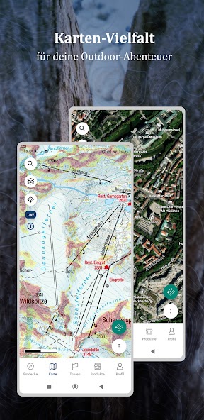
Genuine KOMPASS Hiking and Outdoor Maps
OFFLINE Storage of Maps and Tours
Satellite Map with Additional Information and Points of Interest
Slope Overlay (Alps)
GPS-Location, Live-Tracking
Import of GPX Data
KOMPASS Certified Hiking and Biking Tours with descriptions
Tour Filtering (Difficulty, Distance, Mountain hut…), Tour Types, Elevation Profiles
Digital Hiking and Biking Guides for Various Holiday Destinations
Em www. KOMPASS .de/Outdoorkarte/, os membros do Pro têm acesso a mapas adicionais (transporte público, topografia, Suíça), planejamento avançado de turnê e uma pesquisa clara e rápida de turnê. Saved tours are automatically synchronized with the app.
FREE TRIAL PERIOD OF THE PRO SUBSCRIPTION:
The app with basic features (base map, location, tour recording) is free ( KOMPASS Basic). With a KOMPASS PRO membership, you have access to all features and content. After registering, we offer you a trial period for PRO (activatable on www. KOMPASS .de in your profile settings). The subscription ends automatically.
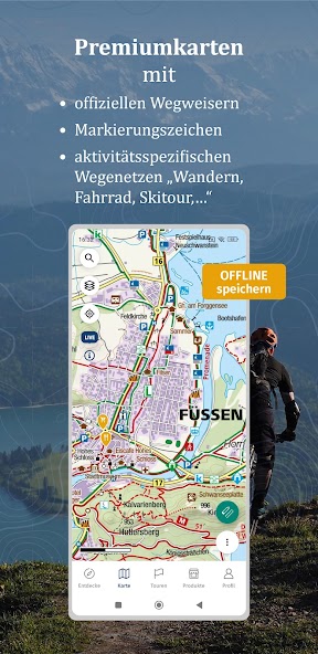
THE GENUINE HIKING MAPS & OUTDOOR MAPS:
Our maps strike the ideal balance between content density and clarity. Not every hiking trail is a via ferrata, and not every mountain hut is accessible by a mountain bike trail. Paths, trails, and climbs, rest stops, viewpoints, landmarks, etc., are clearly marked or labeled. As a PRO member, you can easily read this information and more from the map materials of over 500 KOMPASS hiking maps.
THEMATICALLY MARKED TRAIL NETWORKS:
Hiking and biking trails, bike parks, trails, via ferrata, ski tours, cross-country ski tracks
Quality hiking trails: certified by the German Hiking Association
Long-distance hiking trails: E-paths, Camino de Santiago, Via Romea, …
Long-distance cycling trails: Weser Cycle Path, Elbe Cycle Path, EuroVelo, …
Conduct and Disclaimer:
All trails and tours are researched to the best of our knowledge and are intended as suggestions. Use them at your own risk. A condição real e a usabilidade de trilhas e terrenos podem mudar temporariamente ou permanentemente devido a eventos naturais, proprietários de terras e mudanças estruturais. Data updates occur after research. Always adhere to any prohibitions, signs, and markings on-site. Current local inquiries are necessary. KOMPASS -Karten GmbH cannot assume liability under any circumstances.
About KOMPASS -Karten GmbH:
Since 1953, KOMPASS has stood for reliable quality. We are the world's largest producer of high-quality hiking, biking, and ski tour maps. Em nossa linha versátil, todo entusiasta do ar livre pode encontrar o produto certo: do norte da Alemanha até a Áustria à Itália, Ístria, Maiorca e Ilhas Canárias.
www. KOMPASS .de/produkte/produktfinder/
Further Information and Notes:
Continuous use of GPS can significantly reduce battery life.
In the App Store, you can manage subscriptions, cancel them, and disable automatic renewal after purchase.
For questions or comments, contact: support@ KOMPASS .at
Privacy Policy: www. KOMPASS .de/service/datenschutz/
Terms of Use: www. KOMPASS .de/ KOMPASS -pro-allgemeine-geschaefts-und-nutzungsbedingungen/
 Download(90.87MB)